
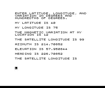
A satellite dish calculator. Enter your latitude, longitude and local magnetic variation in degrees and hundredths, and the longitude of the satellite; the program prints the azimuth, the elevation and the compass heading, or says how far below the horizon the satellite is. It then asks for another satellite. It works in radians internally and converts the results back to degrees. Adapted from a program in Electronics magazine; the article says it runs on the TS2068 too.
As printed, line 280 reads LET E=E+180/PI where it should multiply, so the elevation comes out wrong (about 57 degrees too high); change the + to *. Line 380 also skips the results for a site south of the equator with the satellite to the east.
Published in Syntax March 1984 (Look Angles).
Image Gallery
Source Code
   5 REM PROGRAM TITLE "LOOK ANGLES"
  10 REM - THIS PROGRAM COMPUTES ELEVATION ANGLE, AZIMUTH, AND COMPASS HEADING TO SYNCHRONOUS ORBITING SATELITES.
  20 PRINT "ENTER LATITUDE, LONGITUDE, AND  VARIATION IN DEGREES AND        HUNDREDTHS OF DEGREES."
  30 PRINT
  40 PRINT "MY LATITUDE IS ";
  50 INPUT B
  60 PRINT B
  65 PRINT
  70 PRINT "MY LONGITUDE IS ";
  80 INPUT C
  90 PRINT C
  95 PRINT
 100 PRINT "THE MAGNETIC VARIATION AT MY    LOCATION IS ";
 110 INPUT M
 120 PRINT M
 125 PRINT
 130 PRINT "THE SATELLITE LONGITUDE IS ";
 140 INPUT S
 150 PRINT S
 155 PRINT
 160 REM -Y IS SAT ALT IN KMS
 170 REM - R IS EARTH RADIUS IN KMS
 180 LET R=6370
 190 LET Y=35800
 200 LET G=S-C
 210 REM LINES 220 AND 230 CONVERT DEGREES TO RADIANS.
 220 LET G=PI*G/180
 230 LET L=PI*B/180
 240 LET Q=(COS G)*(COS L)
 250 IF ABS (Q)=1 THEN LET E=90*Q
 260 IF ABS (Q)=1 THEN GOTO 300
 270 LET E=ATN ((Q-R/(Y+R))/SQR (1-Q**2))
 280 LET E=E+180/PI
 290 REM  LINE 280 CONVERTS RADIANS TO DEGREES.
 300 IF E<0 THEN GOTO 460
 310 IF (SIN L)<>0 THEN GOTO 340
 320 LET A=90*SGN (SIN G)+180
 330 GOTO 390
 340 LET A=ATN (TAN G/SIN L)
 350 LET A=(A*180/PI)+180
 360 IF (SIN L)>0 THEN GOTO 400
 370 LET A=A-180
 380 IF (SIN G)>0 THEN GOTO 450
 390 LET A=A+360
 400 LET H=A+M
 410 LET H=H-360*INT (H/360)
 420 PRINT "AZIMUTH IS ";A
 425 PRINT
 430 PRINT "ELEVATION IS ";E
 435 PRINT
 440 PRINT "HEADING IS ";H
 445 PRINT
 450 GOTO 130
 460 LET D=-E
 470 PRINT "ELEVATION IS BELOW HORIZON BY ";D ;"DEGREES."
 475 PRINT
 480 GOTO 130
Note: Type-in program listings on this website use ZMAKEBAS notation for graphics characters.